The fall storm season is on with a vengeance. When the wind starts to howl we get waves on both sides of the lake. Today the wind is at gale force with 50 knot winds out of the west.
The result of the storm weather is this picture:

This fall storm on Lake Michigan is blowing at 50 knots directly out of the west and is creating, according to NOAA, 14-19ft waves on Lake Michigan near shore. Despite the sheer magnitude of this storm, the size of the waves, and the wind speed, this is horrific weather for surf kayaking. You can’t break out because of the direct on shore wind. The wind basically keeps you on the beach. When you set your paddle down to put your spraydeck on, your paddle blows away down the beach. Your gelcoat is sand blasted by the sand on the beach. You might actually make it off the beach, but then just get pummeled by the surf that you can’t make any progress against because of the force 10 winds.
Also the waves, if you managed to break out are so squashed down by the wind that you aren’t likely to find a well formed wave in a set to drop in on. So the overall recommendation is to stay on the beach until the storm has peaked. After about 4 years chasing storms, driving to the beach to find the storm is so strong I can’t even catch a wave, here are the conditions I look for in both the launch spot, or break, and the weather.
- A sizeable storm of sufficient magnitude to last several days with winds over twenty knots (as is the case with the current storm).
- A northerly or southerly bend in the wind direction in order to take advantage of a pier, or jetty as a wind and wave break.
- Wait until the after the peak of the wind has hit, and watch the wave formations, not just the wind.
- Triangulate using the webcams, Spyglasshill.com and the Lake Michigan cam. In this way you can see how things are moving on both sides of the pier. If it is dead on the north side in a north westerly gale, it will be dead on the south end of the pier as well. However if it is blowing at 25 knots and looks gnarly on the north side, it might be perfect on the south side.
Wave formations around piers are the best way in a small surf kayak to get waves like they form on the ocean. On the last day of a storm, when the wind begins to die off, the waves will form into uniform periods and sets and become nice and glassy. The waves are rather crumbly at the top when the wind is up above 30 knots as they are in the picture. These are the waves you want, not the waves at the peak of the storm.
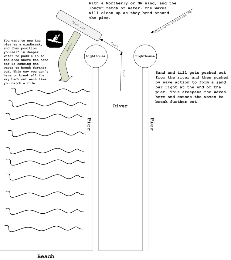
This diagram gives a really good picture of the sort of conditions and the area in which to catch waves. This may hold true for ocean waves under some conditions as well, but is pretty specific to the eastern shore of Lake Michigan during fall. (it’s pretty niche I know).

This diagram of wave formation for surfing and surf kayaking on the great lakes shows what I think about every time the wind starts to blow. And unfortunately what a huge nerd I am.
Very helpful description, Keith!
Wow Kieth! Very nice description of what to look for in deciding to drive or take the day/afternoon off. The best surf I've gotten this year was as you described, after the wind had dropped, and things evened out.
Looking forward to some waves on this side of the lake.
Nice writeup!